|
|
Marvelous Maps and Curious Cartography, Part Three
 "QUANTUM SHOT" #817 "QUANTUM SHOT" #817
Link - article by Simon Rose and Avi Abrams
"I have an existential map. It has 'You are here' written all over it." -- Steven Wright
Here’s another look at intriguing and sometimes bizarre maps here at Dark Roasted Blend. You can also check out Unusual and Marvelous Maps and Unusual and Marvelous Maps Part Two.
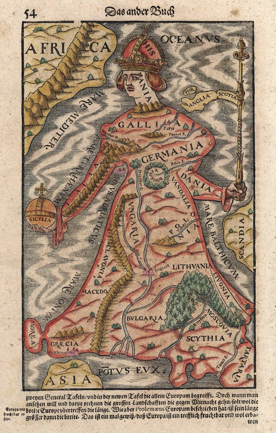
There have been lots of fanciful maps depicting countries as unusual characters. Here’s a 1570 map of Europe as a queen:

(image via)
These caricature maps of England and Scotland appeared in the 1790s:

(images credit: Yale University Library)
Here’s the Korean peninsular depicted as a tiger:

(left image via; on the right are antique prints via Museen Koeln)
And France is shown in the form of a sailing ship:

(image via)
Not quite a mythical kingdom, but this map shows a part of the world that certainly proved to be nonexistent as early explorers searched for the Northwest Passage:

(image via Princeton University Library)
Here we have the USA with each state defined by types of beer:

(images credit: Aleheads.com)
Speaking of tasty beverages, this map shows Europe’s three alcohol areas. The north is for distilled spirits and the south for wine, with beer in the middle:

(image via)
World War 1 served as inspiration for many map illustrators, as shown in these examples:


(images via, click to enlarge)
From the same era this map of an expanded Germany appeared in “Germany's Future” according to an officially circulated pamphlet published in early 1917:

(image credit: University of Texas, click to enlarge)
This one shows Germany’s plans for Africa in 1917:

(image credit: University of Texas)
Here are a couple of Cold War maps, showing the situation in Europe and Asia in the early 1950s:

(image credit: the Time Magazine issue of March 10, 1952, via)
This is a somewhat amusing map of Europe:

(image via)
Never mind the European Union and the gradual erasing of national borders. How about this? This intriguing map of Europe designed by Freddy Heineken, the Dutch beer tycoon. It comprises small territories with more or less equal, ethnically homogenous populations of between 5 and 10 million. The general idea was that a greater number of smaller states would be easier to govern within a European union than a group of bigger competitive countries continually trying to dominate the group (you can see a list of Heinekin’s proposed countries here):

(image via)
This map shows a hypothetical Europe without Germany!.. There were a few similar plans to this at the close of World War II in 1945. Some were Nazi propaganda, but the Morgenthau plan to dismember Germany did exist and was seriously considered for a while. The Bakker-Schut Plan put together in the Netherlands at the end of the war proposed the annexation of parts of Germany, renaming of towns and cities, expulsion of the population and so on:


(images via 1, 2)
The right map above shows how the borders would have changed if the Allies had used the Morgenthau plan on Germany (drawn by Condottiero).
This very interesting map from 2007 concerns the Polish parliamentary elections. The overlay shows the border between the Russian and German Empires as it existed before World War I. Areas formerly part of Russia backed the conservative Prawo i Sprawiedliwość (“Law and Justice”) party, while those that used to be in Germany tended to support the right-wing liberal Platforma Obywatelska ("Civic Platform") party:

(image via)
An intriguing view of the United States, as seen from Japan apparently:

(image via)
Another US map, this one depicting gangland Chicago in 1931 (click here to zoom in):

(image credit: University of Illinois Library, via Chicago History Journal)
How about this map of the United Kingdom, featuring Brit Lit or all the major figures in literature over the last several hundred years? There’s even a place for Bram Stoker on the North Yorkshire coast near Whitby, which of course is one of the locations in the famous novel:

(image via Strange Maps)
Also on a literary theme, here’s a map all about book publishing. Countries are shown by the size of their domestic publishing markets. Europe, Asia and the USA are huge, indicating the strength of their publishing industries. In contrast, Africa and the Middle East hardly feature in the map, since the number of books published in those regions is very low compared to other areas of the globe:

(image via)
Another distorted map, this one showing a country’s size based on its population:

(image via)
And finally, on a similar theme, here we see how the map of the world would be transformed if the inhabitants of the countries with the largest populations moved to the countries with the largest geographic area. Interestingly, although China would take over Russia, Indonesia moves into China, Pakistan becomes Australia and Canada becomes India, the United States, Brazil and a few other countries stay where they are:

(image by JPalmz, based on Wiki info, via, click to enlarge)
Article by Simon Rose and Avi Abrams, Dark Roasted Blend.
READ PART TWO HERE ->
READ PART ONE HERE ->
Also read our HISTORY series ->
|
|
RECENT ARTICLES:
"Dark Roasted Blend" - All Kinds of Weird and Wonderful Things, Discovered Daily!"
DRB is a top-ranked and respected source for the best in art, travel and fascinating technology, with a highly eclectic presentation. Our in-depth articles in many categories make DRB a valued online magazine, bringing you quality info and entertainment every time you visit the site - About DRB
Connect with us and become part of DRB on Facebook and Twitter.
YOUR COMMENTS::
READ OTHER RECENT ARTICLES:
CATEGORIES:
Feel-Good! | airplanes | animals | architecture | art | auto | boats | books | cool ads | famous | futurism | food
gadgets | health | japan | internet | link latte | military | music | nature | photo | russia | steampunk
sci-fi & fantasy | signs | space | technology | trains | travel | vintage | weird | abandoned
|
|


1 Comments:
In upper right-hand corner,Map of 「How Japan sees America」is written 「Tengai Makyo」.
Name of a video game.
I think it's fictional world's map.
General Japanese knows about USA more precisely,I guess.
Post a Comment
<< Home