|
|
 "QUANTUM SHOT" #585 "QUANTUM SHOT" #585
Link - article by Simon Rose and Avi Abrams
Hideous monsters devouring ships? Cryptic symbols, correctly showing storm fronts & dangerous currents
We’ve always been fond of maps, from those antique ones showing sea serpents and hideous monsters devouring ships in the vast expanses of the ocean, to those showing what the world looked like in the distant, and not so distant, past. Maps have, of course, been with us in one form or another, for a long time.

Jerusalem is in the center - from "Itinerarium Sacrae Scipturae", by Heinrich Bunting, 1545-1606
Here’s a world map according to Posidonius, from around 150-130 B.C. -


Ptolemy's version of the world, printed ten years before Christopher Columbus' first voyage - image via
The Cantino planisphere from 1502 is the earliest surviving map showing recent discoveries by Portuguese mariners in the east and west. This is thought to be the earliest map of America (other than the map called "America's Birth Certificate", read about it here) and shows the Caribbean islands and parts of Florida coastline, plus Africa, Europe and Asia, along with the coast of Brazil, only discovered a few years earlier (click to see the large version):

Fragment: Europe and Jerusalem

Fragment: Caribbean islands

Fragments: Brazil's coastline (left), Persian Gulf (right)
From a few years later, the Pietro Coppo map of 1520 is one of the last ones to feature the so-called ‘Dragon’s Tail’ leading down from the edge of Asia, based on Ptolemy's idea from 1500 years earlier that the Indian Ocean was almost landlocked:

(image via)
Here’s a great map of the city of Venice, showing most of the major buildings from 1565. Maps in this style are still used quite often on tourist postcards and in guidebooks for the city:

From Asia's "Dragon's Tail" to the Fabulous Sea Beasts
The richly decorated Carta Marina, from 1539 might seem a little crude by today’s standards but modern satellite imaging revealed that the sea monsters shown in parts of the ocean on the map actually correspond to well known storm fronts, dangerous currents and maritime hazards. This was perhaps just a method of depicting this at the time, as a warning to sailors venturing into these areas (click to enlarge):


Fragments shown. Click to see the full version (image via)
This is a similar one, showing the monsters living in the seas surrounding Iceland in the early sixteenth century:

Theatrum Orbis Terrarum, 1570 - image via
A glorious catalog of "sea monsters" inhabiting old maps and mariner's imagination can be seen on this page. Here are some examples:

Natural History of Norway, 1755

Sea Serpents of Buffalo Land, North America, 1872


...and finally: a whale as an island! - published in Novi Orbis Indiae Occidentalis, 1621:

(images via)
Various incarnations of the "Land Down Under" include... Antarctica
The southern portions of the globe were among the last to be charted by Europeans following the Age of Discovery, but the idea of ‘Terra Australis’ had been around since the time of Aristotle in the fourth century BC. There were various theories over the centuries – the Indian Ocean was enclosed on the south by land, that the lands in the northern hemisphere had to be balanced by land in the southern half of the world, or Africa stretched all the way to the South Pole. In 1820, Antarctica was finally sighted in the region always associated with Terra Australis, but here’s a map showing the mythical continent occupying a large chunk of the southern hemisphere from 1587:


This very decorative world map, with Antarctica, as well as parts of North America, still absent, was produced in Amsterdam in 1689. Click to enlarge, very large file, here are some fragments:


Fragments, click to see the whole map
Here’s an Italian map of North America from 1566, one of the first ones to describe the northernmost portions as Canada:

Alternate history in hypothetical maps
The genre of alternate history has produced its fair share of hypothetical maps. Here are a couple depicting what Europe might have looked like had the Greater German Reich triumphed in the 1940’s (click to enlarge).

Fragment, click to see the whole map

Fragment, click to see the whole map
In a similar vein, here is the world in 1964, according to the alternate history novel Fatherland, which was based on the premise that Germany won Word War Two. The Greater German Reich is shown in red, the European Union representing Nazi allies and subject races in maroon, colonial possessions in orange, US possessions and allies in blue with neutrals in yellow:

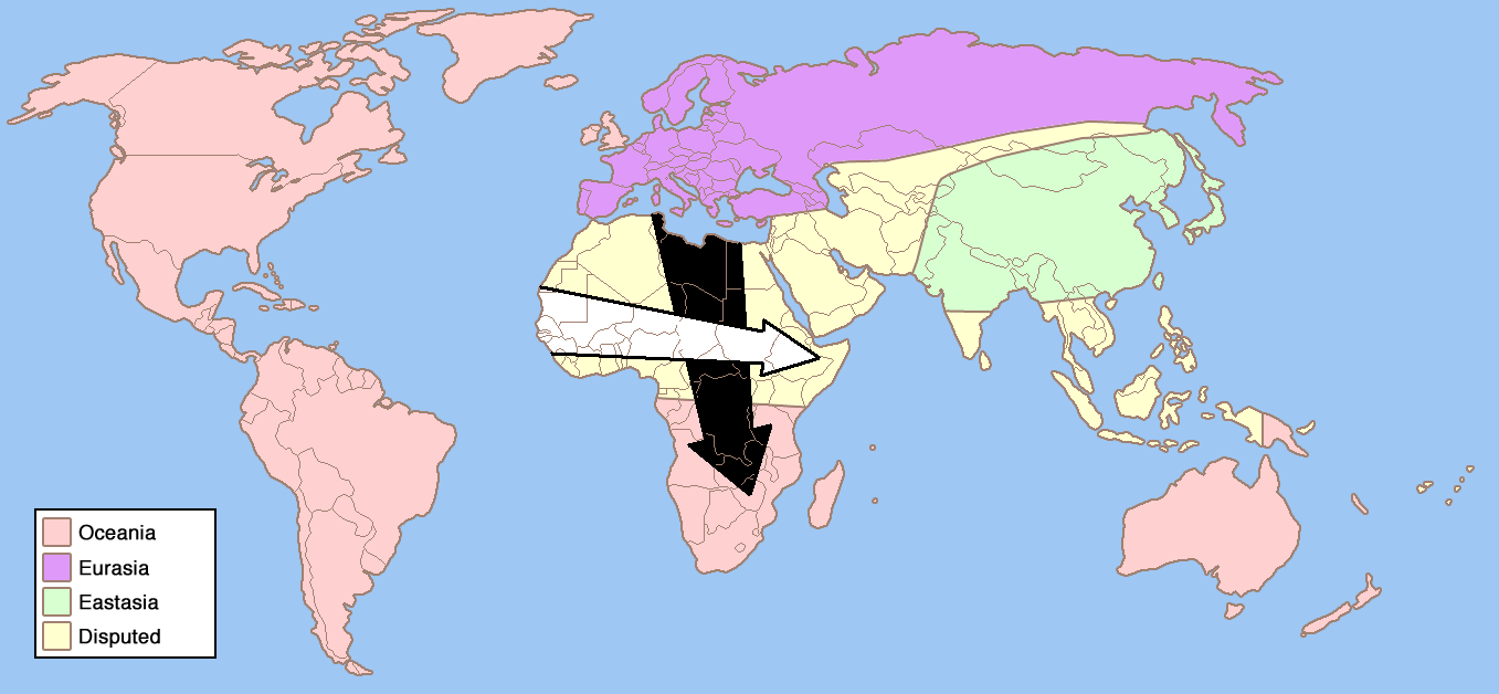
And here is the world as imagined in George Orwell’s novel 1984. The zones of the globe shown as being in dispute, leading to a perpetual state of conflict between the various power blocs, are reminiscent of the struggles of the Cold War in Africa and Asia between the superpowers:

(click to enlarge)
Back in the seventies, C. Etzel Pearcy, a professor of geography, suggested redrawing all the borders of the American states. The country would then comprise thirty eight states, rather than fifty, with each new name representing an area’s physical or cultural distinctiveness. It was never implemented, of course, but very intriguing all the same:

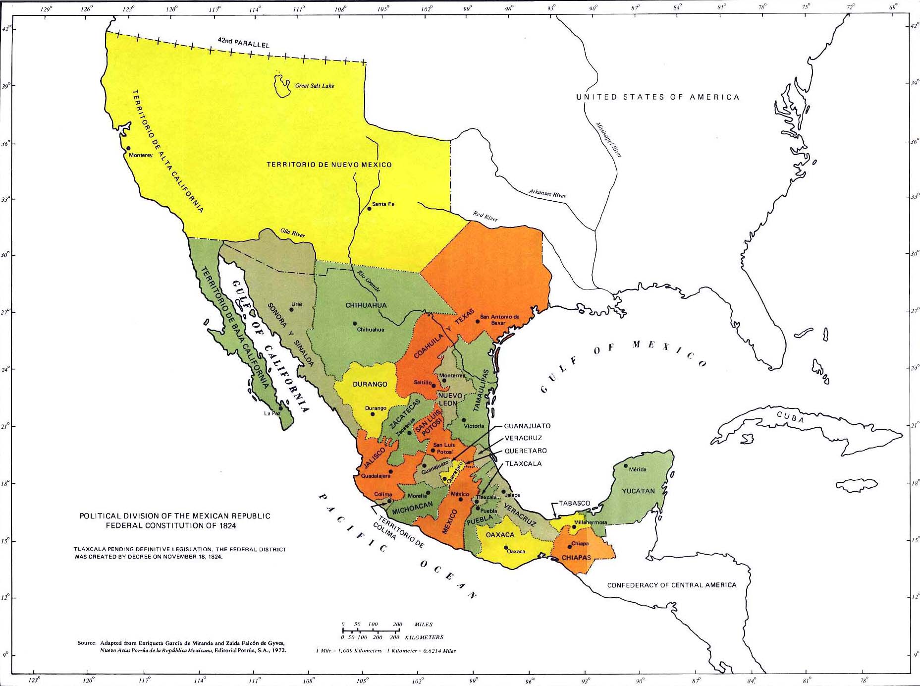
Still on the topic of redrawing US borders, this recent Absolut Vodka ad campaign which ran in Mexico caused quite a stir. In the US there were calls to boycott the Swedish vodka, and yet the map has some basis in fact, since Mexico only lost the territories of Alta California and Nueva Mexico following the Mexican-American War of 1846-1848. Mexico ceded 42% of its territory, which later became California, Nevada and Utah, plus parts of Arizona, Colorado, New Mexico and Wyoming. Absolut decided to issue an apology, pointing out that the ad was created for the Mexican market and did not mean they were protesting immigration issues, fostering anti-American sentiments, demanding a redrawing of borders and so on, in an attempt to defuse the issue:

For those non-believers, here is a genuine map of Mexico in 1824, showing the territory later lost to the United States:

(click to enlarge)
Most students of history will be familiar with this map of Africa, completely dominated by European powers just before the First World War. After 1918, the German colonies were divided between Britain and France and Africa remained under the foreign control for decades to come. Colour coding is as follows: Britain red, France blue, Portugal purple, Germany light green, Spain pink, Italy emerald green, Belgium yellow. Only Ethiopia and Liberia, established as a homeland for freed slaves in the mid-nineteenth century, remained independent:

On a similar note, these days it’s hard to imagine that a country as small as Britain once ruled over a quarter of the world’s surface, including huge populations such as those in India. Here is the British Empire in the 1920’s, after the acquisition of the German colonies in Africa and the partition of the former Turkish territories in the Middle East between Britain and France:

This is a caricature map of England by Robert Dighton from 1795:

(image via)
Here are some similar maps from the late nineteenth and early twentieth centuries. This is an Asian view of the world situation around the time of the Chinese revolution of 1912. This map was actually published in Japan, but indicates the belief that there was a lot of foreign influence in China at this time. In this period just prior to the outbreak of war, the Russian bear looms large over Europe and Asia, Britain is depicted as a sea monster, reflecting the country’s position as the world’s predominant naval power at the time, while Germany is shown as a tusked warthog:

(image credit: Bibliodyssey)
This satirical map of Europe dates from 1870, indicating the political situation of the day. England holds Ireland, drawn as a vicious looking dog, tightly on a leash, while France struggles against Prussia:

(image via StrangeMaps)
The so-called Octopus Map is from a few years later. At the time, the Russian Empire was seen as very expansionist and already has its tentacles around Turkey and Persia, but is being held off by Germany:

See another version of this sort of comic map of Europe here
This one, showing an even more aggressive Russian octopus, was created in Japan at the time of the Russo-Japanese War in 1905:

"A Humorous Diplomatic Atlas of Europe and Asia" by Kisaburo Ohara (Japan), 1904 (click to enlarge)
Map of the "Hand of Moscow", pretty hilarious:

(map by R. M. Chapin, Jr., Time)
Superimposing modern political map with Lands and Magical Kingdoms from the Lord of the Rings lore, we get this "correct politial map" version (don't take it too seriously, folks):

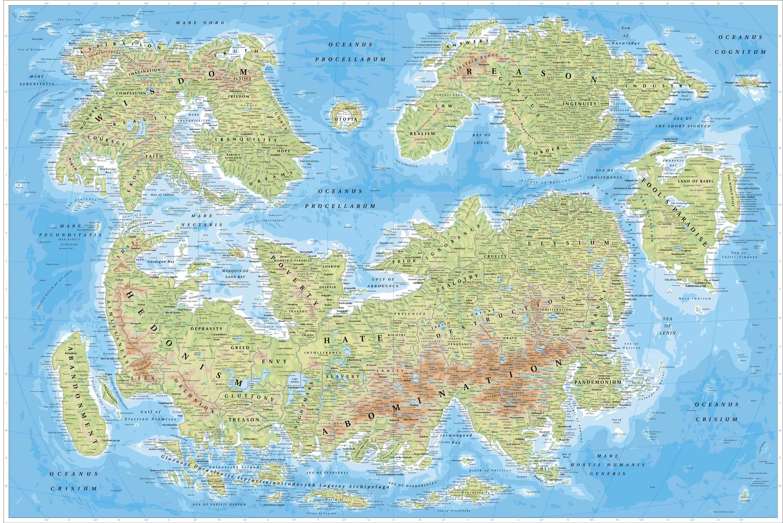
Incredible in its philosophical and psychological depth Map of Humanity can be viewed here.

Click to see the full map. Map credit: JT Illustration
Also don't miss the bizarre post-war New World Map (for the establishing New World Moral Order) - click here. And finally, here’s same old world, but with different perspective, in this reversed version showing north at the bottom of the map.

Order this map here - more info
There is also a "reversed map", showing land where oceans are supposed to be:

(Map made by VladStudio, get your wallpaper size here)
Article by Simon Rose and Avi Abrams, Dark Roasted Blend. We are also grateful for the research and additional material from Marty Weil of Ephemera: The World of Old Paper. Read his interview with antique map collectors David Rumsey and Richard Horwitz
CONTINUE TO PART TWO! ->
|
|
RECENT ARTICLES:
"Dark Roasted Blend" - All Kinds of Weird and Wonderful Things, Discovered Daily!"
DRB is a top-ranked and respected source for the best in art, travel and fascinating technology, with a highly eclectic presentation. Our in-depth articles in many categories make DRB a valued online magazine, bringing you quality info and entertainment every time you visit the site - About DRB
Connect with us and become part of DRB on Facebook and Twitter.
YOUR COMMENTS::
READ OTHER RECENT ARTICLES:
CATEGORIES:
Feel-Good! | airplanes | animals | architecture | art | auto | boats | books | cool ads | famous | futurism | food
gadgets | health | japan | internet | link latte | military | music | nature | photo | russia | steampunk
sci-fi & fantasy | signs | space | technology | trains | travel | vintage | weird | abandoned
|
|


25 Comments:
You missed the latest news:
http://www.newsdaily.com/stories/tre56g583-us-map-america/
http://en.wikipedia.org/wiki/Vinland_map
http://upload.wikimedia.org/wikipedia/commons/d/dd/Vinland_Map_HiRes.jpg
That Absolut ad is actually brilliant. It's too bad that people don't know enough about history or geography to realize it.
You definitely missed this one.
http://en.wikipedia.org/wiki/Piri_Reis
under
Alternate history in hypothetical maps
The first map.
Why is there a yellow circle around Denmark?
Wow, as if sailing in the 16th century wasn't frightening enough, imagine looking over your maps and seeing monsters or whirlpools drawn in right where you are positioned.
Old maps of Africa are my favorites. My dad has a print with the continent covered in exotic tribesmen and strange, uninformed versions of the wildlife.
Fantastic article. I'm really loving the proposed re-structuring of the United States in the 1970s.
I find it very interesting that on the map produced from Amsterdam in 1689 shows that California (which seemed to also include parts of Mexico at the time) is not even connected to the North America. It seems to be separated by water called M Vermezo... I searched for what that might have meant but came up with nothing but a park in Budapest named Vermezo (meadow of blood or bloodfield) due to an execution that took place. I wonder if maybe the original California is now under water and the state that we know it as now was later named... Hmm... very intriguing indeed! Thanks for all the great map examples!
>>That Absolut ad is actually brilliant. It's too bad that people don't know enough about history or geography to realize it.>>
In what way is that brilliant? I can't figure out what the message is supposed to be. Should we interpret "In an Absolute World" as "In a perfect world" or "In a better world?" Would it be better if they showed a map of Germany at the height of Nazi power with the words "In an Absolute World"? This has nothing to do with history at all. We know that the Southwest was owned by Mexico. But, how does that change anything, and how is the ad brilliant?
>>In what way is that brilliant?>>
Wow, it only took 9 comments to break Godwin's Law! The ad is brilliant because it was marketed in Mexico, where there remains a bit of resentment over the takeover of the Mexican Northwest by the United States. Thus, in an Absolut world, they would still have their land.
>>This has nothing to do with history at all>>
Of course it does, that's why it was in the section labelled "Alternate history in hypothetical maps"
Why are those Catholic clergy having mass on the back of that big fish?
Hi people!!!
Where can I find some of these maps at a good resolution for printing?
Eric: here is what we could find - "It shows the whale, Jasconius, in an account of the voyage of Saint Brendan. Some of the monks were preoccupied with mass when the nature of the island became obvious."
Claudio: some of the images are linked to very large-format scans on Wikipedia - you can use those.
Intriguing! Thank you, Avi.
Hi,
Some of these are true works of art.
One needs to remind that most of these are unique and handmade.
Some maps were also created with errors as a way of counterintelligence.
Regards,
José
"there remains a bit of resentment over the takeover of the Mexican Northwest by the United States."
Well, given that you acknowledge that pandering to that nationalist resentment was the point of the ad, I too wonder just what you find so "brilliant" about stoking such passions just to sell vodka. It may be skillfully done, but I don't think it's a terribly bright move on Absolut's part.
If this were a map of the Old Confederacy, under the same headline, would you also sneer at people troubled by such an ad, insinuating that they simply "don't know enough about history or geography" to appreciate its "brilliance"?
Yes, yes I would. You're still talking about the Absolut ad, and isn't that the point of all advertisements? Hence, briliant.
Really Awesome. ( Lisbon/Portugal)
I'm glad to see you gave http://vladstudio.com/ the proper credit for the image of the "reversed map" but you should use the image with the proper name on it, not the one of someone that cropped it and added their own name to it.
ya that absolut ad is genius... if only mexico's corruption, and third worldliness could stretch further.
http://strangemaps.wordpress.com/
Always good stuff for anyone that hasn't been there.
The "whale as an island" refers to St. Brendan:
http://en.wikipedia.org/wiki/Brendan
The second map (according to Posidonius) isn't from 150-130 BC; it's based on his general ideas but was actually drawn in the Middle Ages. There are a lot of details that Posidonius couldn't have known -- for example, the Greco-Roman world didn't know that Britain was an island until Gn. Agricola sent an expedition in the mid-1st century AD.
Vis the Absolut Vodka Map:
why do americans always get self Righteous / Indignant offended soo easily?
It was light hearted and aimed at mexicans.
Its not as thought it was aimed at native american indians showing the pilgrim fathers hanging on to small east coast enclave?
as the other poster indicated... Godwins Law so soon!?
Becuase we all know that the "wild west" is so much in the public domain?
http://bigthink.com/ideas/21343
Just a big play area for the US Federal State (aka Military)
Post a Comment
<< Home